All 31 Sentek soil moisture probes are now installed across the Mulloon catchment, paired with groundwater monitoring sites. Each soil moisture probe has six sensors distributed between 10 and 150cm in depth, which monitor the proportion of moisture at each depth in the underlying aquifers. This will aim to assess how the plant available water in the soil profile interacts with groundwater, and the effect of rehydration actions in the catchment including the implementation of leaky weirs.
Despite some challenges with install due to the March 2021 flood event and some technical issues with transmitting data from remote locations, all instruments are now performing as expected. The soil moisture sensors are transmitting data to a data management system and accessed by TMI scientists via an online portal in near-real time.
The Mulloon catchment has had its wettest 12 months on record and TMI’s scientists and partner HydroTerra are keen to analyse the results following the flood event that rehydrates the floodplains due to the actions of the leaky weirs.
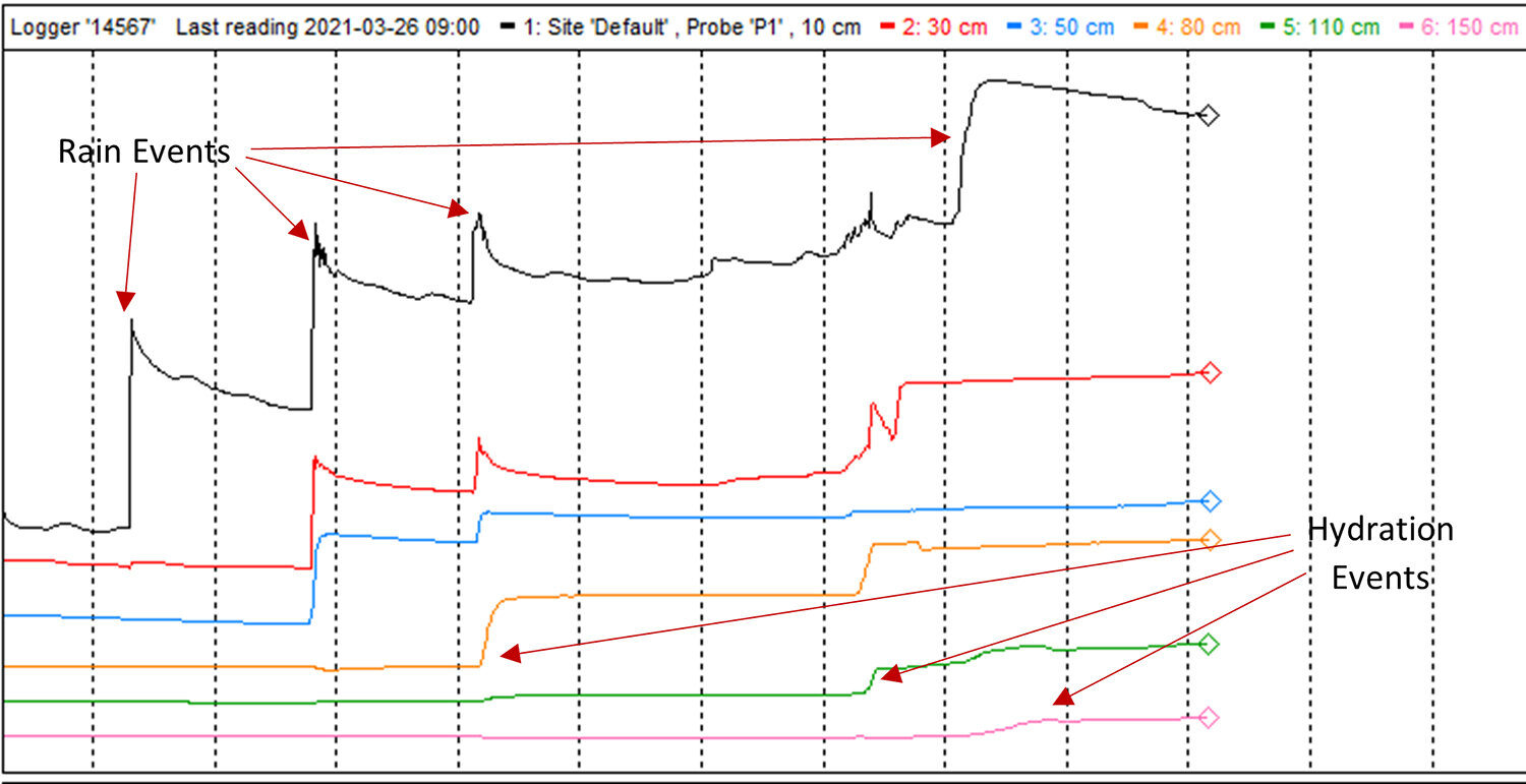
Figure 1: Hydration of the floodplain through infiltration (marked with red arrows).
The significant wet period has produced some fascinating initial results. With each rain event it’s possible to see how much water infiltrates down the soil profile in real time. Figure 1 shows a one-month period where initial rain events hydrate only the upper soil layers, with further rain and continued infiltration the deeper soil zones start to be hydrated. Another means of rehydration is through aquifers carrying water from external sources. Figure 2 shows deep soil hydration from water carried through aquifers from elsewhere in the floodplain.
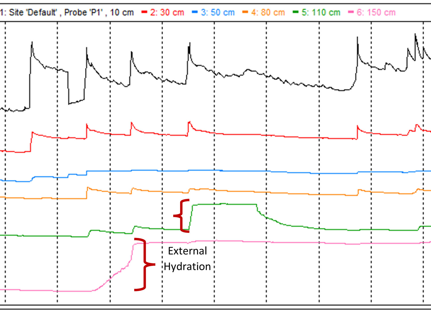
Figure 2: Hydration of deep soil zones from subsurface movement of water (marked in red). This is evident from the soil zones above 150cm and 110cm that show a different moisture profile to their own.
The data acquired from the soil moisture probes will be used in conjunction with pressure and depth information from the paired bore-holes equipped with groundwater monitoring instrument to monitor where all the water goes and create a hydrogeological model of the floodplains. From this model, we will better understand the effects that leaky weirs and contouring can produce in a floodplain environment.
It will be very interesting to see how each of the sites in the Mulloon Rehydration Initiative respond to different climatic extremes such as floods, drought, and heatwaves. To maintain the highest quality dataset, the team is working with HydroTerra to ensure data management processes and integrating all our data into DataStream. TMI and HydroTerra are streamlining the maintenance process by using tablets with software FastFields to ensure that the data is consistent, and all maintenance protocols are carried out following best practice. Stay tuned for further analysis and the reporting that’s forthcoming.
The Mulloon Rehydration Initiative is jointly funded through the Mulloon Institute and the Australian Government’s National Landcare Program. The initiative is also assisted by the NSW Government through its Environmental Trust.


![Workshop in the Capertee Valley involving TMI, Kandos School of Cultural Adaptation, Capertee Valley Landcare and University of Wollongong students, 2020. [Photo: Alex Wisser]](https://mullooninstitute.org/wp-content/uploads/2024/11/untitled-45-600px.jpg)