
Above: L-R: Wilfred Finn (Mulloon Law Committee), Trudy Weirs (MLC), Gary Nairn AO (Chairman), Carolyn Hall (CEO), Matt Egerton-Warburton (MLC, Chairman)

Mulloon Institute held an information evening at NSW Parliament on 4 March 2020 to showcase proposed legislation amendments by the Mulloon Law Committee, which aim to help facilitate the efficient construction of Landscape Rehydration Works throughout NSW.

Speakers included Mulloon Institute’s Chairman Gary Nairn, CEO Carolyn Hall, Trudy Sheehan from King & Wood Mallesons (Planning), AITHER’s Wilfred Finn (Water) and Gadens’ Matt Egerton-Warburton from the Mulloon Law Committee

The event was hosted by the Hon. Rob Stokes MP, NSW Planning and Public Spaces Minister with 140 attendees including farmers and landholders, supporters, politicians and ministerial staff.

The forum covered planning and approval issues encountered by the Institute and landholders when attempting to remediate catchments. At its extreme, approval for one project took 30 months and cost $350,000, but cost less than $100,000 and took only three weeks to construct. The Mulloon Law Committee has drafted legislation to streamline this process with the aim of expediting the establishment of landscape rehydration works while meeting necessary regulations.

Earlier in the week representatives from Mulloon met with NSW Planning Minister Rob Stokes, NSW Water Minister Melinda Pavey, Deputy Premier John Barilaro, NSW Agriculture Minister Adam Marshall and senior policy advisors from NSW Environment Minister Matt Keen‘s office to discuss adjustments to the current compliance processes that are hindering farmers from building much needed landscape rehydration structures.

Ministers Stokes and Pavey made commitments to actively consider the proposed amendments to facilitate the construction of more landscape rehydration works across the state for catchment-scale landscape repair, drought and bushfire prevention.

Leaky weir construction at Westview Farm in Mulloon, NSW (November 2018)

Leaky weir construction at Westview Farm in Mulloon, NSW (November 2018)

MEDIA RELEASE – 3 March 2020

The NSW Government will “actively consider” amending water and planning legislation to facilitate the construction of more landscape rehydration works across the State for catchment-scale landscape repair, drought and bushfire prevention.

Representatives from The Mulloon Institute, which focuses on rehydration and repair of agricultural landscapes, met with NSW Planning Minister Rob Stokes and NSW Water Minister Melinda Pavey on Monday to discuss adjustments to the current compliance processes that are hindering farmers from building much needed landscape rehydration structures.

The most commonly used land rehydration structures are ‘leaky weirs’ – engineered natural structures that slow the flow of water in creeks and gullies, raise water levels and rehydrate floodplains and underground aquifers. 

In Australia, over-grazing and land clearing have caused landscapes to dehydrate, creating eroded and degraded watercourses, and an increased susceptibility to drought and bushfires. To repair these watercourses, the Institute facilitates the construction of leaky weirs and related landscape rehydration works such as embankment restoration and watercourse plantings. 

At present, catchment remediation with multiple landowners is difficult due to requirements for individual approvals for each structure; submissions from each landowner to multiple departments; and costly expert reports. The time and costs of complying with the necessary approvals and reporting requirements can be three to four times higher than the cost of building the landscape rehydration works.

The Mulloon Institute’s proposed amendments would make leaky weirs and related rehydration works ‘exempt’ or ‘complying’ developments, which in turn would expedite the establishment of landscape rehydration works while meeting necessary regulations.

The Mulloon Institute Chairman, Gary Nairn said: “We are delighted to have received commitments from Ministers Stokes and Pavey to actively consider implementation of the amendments we are proposing. We would like to see a situation where, as long as the works comply with NSW codes, our farmers can just get out there, build these structures and repair their land.” 

Leaky weir at Westview Farm in Mulloon, NSW (February 2019)

Leaky weir at Westview Farm in Mulloon, NSW (February 2019)

Ultimately, landscape rehydration structures work to re-establish Australia’s natural wetlands, chains of ponds and swampy meadows. The resultant rehydrated landscapes significantly increase resilience to drought and decrease susceptibility to bushfire.

“With drought still crippling some areas of rural NSW, some severely impacted by the recent bushfires, and some dealing with flooding rains, never has effective water management been so crucial for our agricultural industry and sustainable environmental management.

“For farmers and graziers, landscape rehydration is a scientifically backed drought-proofing method of improving conditions on their properties and, importantly, allowing for returns to be generated in periods of severe drought, as we’ve recently seen.

“The laws in place protect the environment, biodiversity, water quality and supply. We believe our landscape rehydration structures fulfil these mandates. We’d like to see the legislation adjusted to recognise the value of these works and allow compliant projects to proceed with necessary certification attained later. 

“Landscape rehydration initiatives leave us with landscapes better equipped to withstand drought, less susceptible to bushfires, and more environmentally sound. To achieve these benefits, we believe facilitating landscape rehydration works through legislative reform should be a key priority of the NSW Government,” said Mr Nairn

Journalists are invited to The Mulloon Institute Information Evening hosted by the Minister for Planning Rob Stokes tomorrow night at 7:00pm at NSW State Parliament.

The Mulloon Institute Chairman, Gary Nairn, will be available for media interviews.

Further details, including RSVP.

https://themullooninstitute.org/events/2020/3/4/7nrditxi0wp1ozv053zdjxrui49a37

– ENDS –

Media contact 
Jane Munday
FTI Consulting

Jane.Munday@fticonsulting.com | 0488 400 248


Further Information:

NSW Ministerial Briefing Paper

A group of school students, their parents and neighbouring farmers from Belltrees, NSW visited Mulloon Creek Natural Farms as part of a four day tour to regenerative agriculture practitioners.

We are so fortunate to be able to share our knowledge of landscape rehydration and regenerative agriculture with the up-and-coming future farmers of Australia! Thanks for visiting us Belltrees Public School.

Photos from last week’s ‘Regenerative Agriculture – A Deep Dive into Fire, Carbon and Water’ event that formally launched the Clean Energy Regulator‘s Handbook for farmers wanting to learn how to join the Carbon Market. Event hosted by Carbon8 at Mulloon Creek Natural Farms.

Carbon8-600px.jpg

Image: Approved creek works undertaken at Westview Farm in 2018.

Image: Approved creek works undertaken at Westview Farm in 2018.

The Mulloon Institute invites you

To an information evening to showcase amending legislation proposed by the Mulloon Law Committee to facilitate the efficient construction of Landscape Rehydration Works throughout NSW. Kindly hosted by the Hon. Rob Stokes MP, NSW Planning and Public Spaces Minister.

WHEN – Wednesday 4 March 2020
TIME – 7pm – 8.30pm
WHERE – The Parliamentary Theatrette, NSW State Parliament

Invitees

All interested members of the public including Members of Parliament and their staffers, media and friends of The Mulloon Institute.

RSVP

By Friday 28 February 2020 to Jodi.Griffin@gadens.com

Triple Ponds, Mulloon Creek in 2006 (left) and in 2013 (right).

Triple Ponds, Mulloon Creek in 2006 (left) and in 2013 (right).

Landscape rehydration is a key priority in agricultural areas around Australia, with approximately 60% of Australia’s valuable agricultural land degraded and continuing to degrade. These dehydrated landscapes have been negatively affected by soil erosion, compaction, loss of organic matter and the draining of wetlands.

Continuing degradation of floodplains, slope erosion and land clearing has affected the resilience of our catchments to respond to these challenges with devastating consequences, including reduced:

  • biodiversity

  • water and soil quality and quantity

  • productivity of agricultural landscapes

  • natural fertility

  • resistance to weed invasion

  • resilience of landscapes during climatic changes

  • drought resilience and increased susceptibility to bushfires.

Prior to European settlement

Prior to European settlement

In the Mulloon catchment east of Canberra, the introduction of European farming in the 1820s (and with it a suite of new plant and animal species) resulted in a disruption to the delicate, energy-dissipating balance that had existed between vegetation and the water cycle.

As Johnston and Brierley (2006)* contend, the stream throughout much of the lower Mulloon catchment was discontinuous prior to European settlement, with water moving slowly through a chain of ponds, surrounded by grassy floodplains. When these ponds flooded, water spread across the floodplain, depositing sediments and nutrients and banking water in the landscape. The ponds even remained full during times of drought.

Today, much of the Mulloon catchment and its tributaries are deeply incised, which has serious implications for the catchment’s:

  • water holding and water filtering capacity

  • biodiversity

  • ability to sequester carbon (which is significantly higher in hydrated soil)

  • water table height (and the ability of vegetation to access such water)

  • agricultural productivity

  • resilience to extreme events such as droughts, floods and wild fires.

Since European settlement

Since European settlement

This decreased resilience to climatic changes and extreme natural events is particularly relevant and alarming amid Australia’s current bushfire crisis and the ever-emerging consequences of climate change. With the severity and frequency of Australian droughts and fires expected to intensify because of climate change, it is vital that landscape rehydration initiatives such as the Mulloon Community Landscape Rehydration Project (MCLRP), which enhance resiliency to fires, droughts and floods, are proactively supported and implemented with urgency.

The MCLRP being implemented by The Mulloon Institute aims to rebuild the Mulloon catchment’s natural landscape function and boost its resilience to climatic extremes for more reliable stream flows, improved ecosystem functioning and enhanced agricultural productivity. The project spans 23,000 ha, 50kms of creeks and tributaries and involves over 20 local landholders.

Installation of leaky weir at Westview Farm as part of the MCLRP.

Installation of leaky weir at Westview Farm as part of the MCLRP.

Landscape rehydration works are also one of the best practical actions communities can undertake to improve water quality in the wake of bushfires. Bushfires have the potential to degrade waterways as runoff can carry sediment and pollutants that affect the aquatic environment, drinking water quality and water-reliant industries such as agriculture. In the Mulloon catchment, wetlands recreated through the MCLRP are playing an important role in filtering runoff from the December 2019 bushfire in nearby Tallaganda National Park as the MCLRP runs into the Shoalhaven River, which feeds into the Sydney water supply.

* Johnston, P. & Brierley, G. (2006) Late Quaternary River Evolution of Floodplain Pockets along Mulloon Creek, New South Wales, Australia, The Holocene, Volume 12, No. 5, pp 661 – 674.

[Article published in the Carwoola Gazette, February-March 2020.]

2020-Dec-January-600px.jpg

Read our latest news: https://conta.cc/31xe3m5

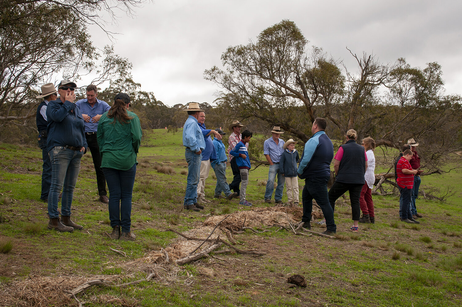
Many land managers are looking for ways to protect their land resources and waterways and initiate recovery following recent fires in Australia. 

We all want some decent rain, but high intensity, high volume rainfall can cause further degradation through soil erosion and washing away any remaining organic material and ash into dams and other waterways. This has the potential to cause major issues with water quality that can affect the health of humans, stock and other plants and animals that rely upon this water.

So what can be done?

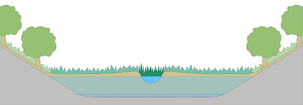
Slow the flow of water across the land, particularly on sloping land.

This helps de-energise the water’s flow across the land which in turn reduces erosion, captures any sediment and organic materials, and gives the water a better chance to infiltrate the soil.

There are a range of actions that can be used depending on the slope of the land, soil type, what materials and resources you have available, and how much time you have to implement them. Some resources mentioned might be difficult to source in certain fire effected circumstances.

Begin your remedial works on areas of importance or those at highest risk of further damage.

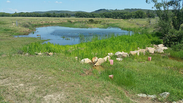
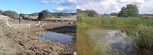
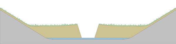
Previous erosion sites

Look for signs of where previous erosion has occured. The best place to conduct erosion control measures can often be upslope of the erosion area. It is also a good idea to cover any bare and eroded areas with organic material to provide some protection from further erosion.

Contours 

These can be made of mulch or other organic materials you have on hand.

  • Roll out a round bale of hay using fallen log or branches to hold it in place.

  • Brush-packs, as described by David Tongway (CSIRO) in the link below, can be made from tea-tree or other dense shrubs, or tree branches. If harvested properly most plants will re-sprout in due course.

https://site.emrprojectsummaries.org/2016/03/06/brush-pack-experiment-in-restoration-how-small-changes-can-avoid-leakage-of-resources-and-underpin-larger-scale-improvements-for-restoration-and-rehabilitation/

  • If compost is available put this under the mulch or logs and branches to ensure contact with soil and protect from washing or blowing away

  • Contours made of soil pushed up by a blade plough or similar tool. Be careful to get the contour correct or this could lead to channelling water and cause concentrated water to break through or run out the end, causing more erosion.

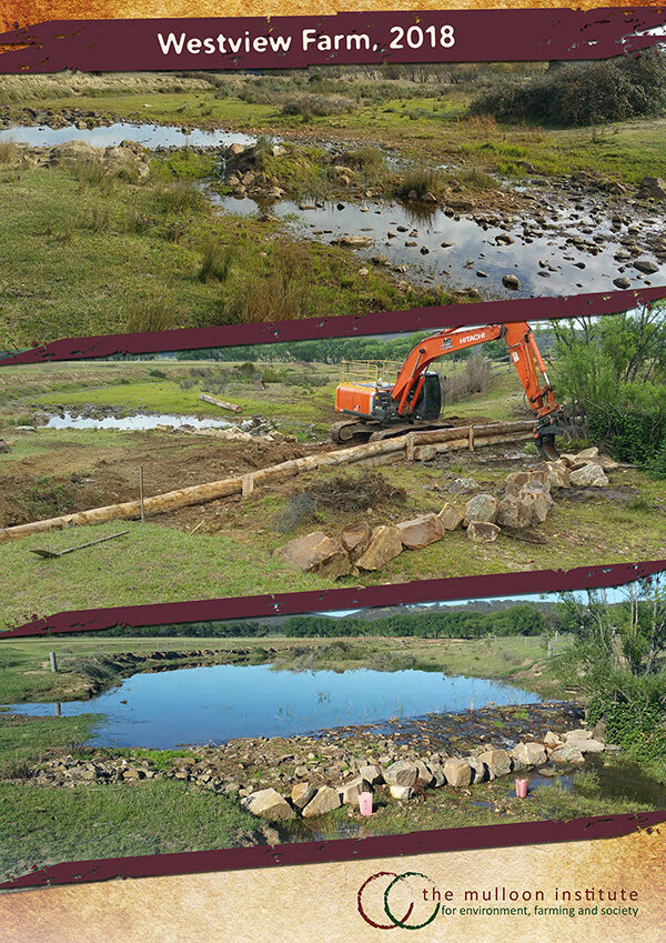
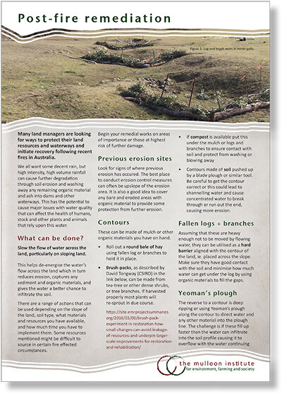
Fallen logs + branches

Assuming that these are heavy enough not to be moved by flowing water, they can be utilised as a hard barrier aligned with the contour of the land, ie. placed across the slope. Make sure they have good contact with the soil and minimise how much water can get under the log by using organic materials to fill the gaps.

Yeoman’s plough

The reverse to a contour is deep ripping or using Yeoman’s plough along the contour to direct water and any other material into the plough line. The challenge is if these fill up faster than the water can infiltrate into the soil profile causing it to overflow with the water continuing its downslope journey, carrying the soil and organic material with it, and potentially causing the same erosion problems.

Small obstructions

It is generally better to create many small obstructions that slow the water flow rather than building one large obstruction. The purpose is to slow the water flow and allow it to leak through the structures, not to dam the water as this can lead to potential failure and erosion.

Brush-packs

Brush-packs are structures that mimic the functioning of naturally occurring fallen branches. They slow overland flows at ground level and create wind turbulence up to a half a metre above them allowing them to capture airborn particles and materials. Typically they are made of branches, twigs and leaves.  

Experimental brush-packs designed for maximum effect accumulate soil particles and trap plant litter, leading to improved nutrient cycling, increased soil health and permeability (Tongway & Ludwig 1996).

Brush-packs made from tree loppings can be used to arrest surface erosion and create micro-habitats for new plantings. The heavier woody material needs to be in contact with the soil surface across the full length of the branch and heavy enough to withstand any overland flow rates from rainstorms. 

Begin constructing your brush-pack  upslope where flow rates are lower and then progress towards the lower slopes. The brush-pack only needs to be about 1m wide in the upslope/downslope direction and then around 1.5 to 2m along the contour, or as long as you have material for. This makes all the material able to be placed manually. The brush-packs are intended to be leaky weirs, not dams.

It is also important to have about 40-50 cm height of “springy twigs” above the heavier branches both to create wind turbulence and prevent large herbivores like kangaroos from grazing new grass plants down to the ground. The springy twigs should still be attached to their branches.  If the slopes are steep or animal disturbance is likely to be high, the branches could be secured in place with hardwood stakes or pegs. Note however, that rabbits could still graze beneath the twigs and make the brush-pack a site for a warren, so consider rabbit control as part of the strategy.

Who are we? 

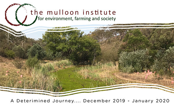
The Mulloon Institute is a not-for-profit organisation actively demonstrating and sharing innovative regenerative land management practices. 

Disclaimer

Where water flow is concerned there are substantial risks involved. While the information and images included are formulated in good faith, with the intention of raising awareness of landscape rehydration processes, the contents do not take into account all the social, environmental and regulatory factors which need to be considered before putting that information into practice. Accordingly, no person should rely on anything contained within this document as a substitute for specific professional advice.

DOWNLOAD ‘Post-fire remediation’ flyer

EN_CARD6_storewater-600px.jpg

Why do we LOVE wetlands!?!

Wetlands are so important. They filter the air and the water; they capture pollutants and recycle nutrients; they are full of biodiversity; they are wildlife nurseries and refuges; they dissipate solar energy and moderate climate extremes; and, they capture carbon and build landscapes.

While 95% of the world’s wetlands have been destroyed or are severely degraded, at The Mulloon Institute we are turning this story around by rehydrating landscapes across the country. We are working with Landcare groups, Catchment Management Authorities, NRM groups and innovative farmers who are passionate about restoring the health of the Australian countryside, including this most critical component of our living planet – wetlands!

Our major flagship project is the Mulloon Community Landscape Rehydration Project, covering 23,000 hectares of the Mulloon catchment in southern NSW, and encompassing around 50 km of creeks and tributaries. The project involves over 20 local landholders and forms a critical biodiversity corridor that connects the Tallaganda National Park with the protected State Reserve of the Mid-Shoalhaven water catchment.

Join us in celebrating how important wetlands are this World Wetlands Day!

Maritn Royds Jillamatong in front of weir-600px.jpg

Back in December 2019, firefighting helicopters were filling up from leaky weirs on Martin Royds’ Jillamatong property to fight the fires threatening Braidwood. 

Martin Royds is a longtime regenerative farmer who has rehydrated a large erosion gully on his property using Peter Andrews’ methods. What was once an intact chain of ponds at the time of early settlers and had since become a deeply eroded gully, is now a series of well hydrated leaky weirs. 

According to Martin, who also sits on The Mulloon Institute‘s Board, the weirs’ ability to endure during times of drought comes down to natural sequence farming and regenerative agriculture.

Read the full article here:
https://www.theland.com.au/story/6554043/weirs-flow-helps-firefighters/

SOURCE: The Land, article by Olivia Carter, 20 December 2019