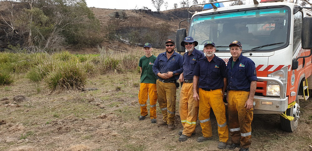
Like so many thousands of other Australians this summer, The Mulloon Institute’s Peter Hazell, and his wife Donna, were confronted with the full fury of bushfire recently.
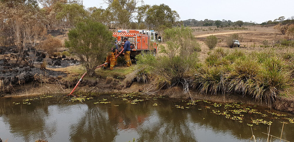
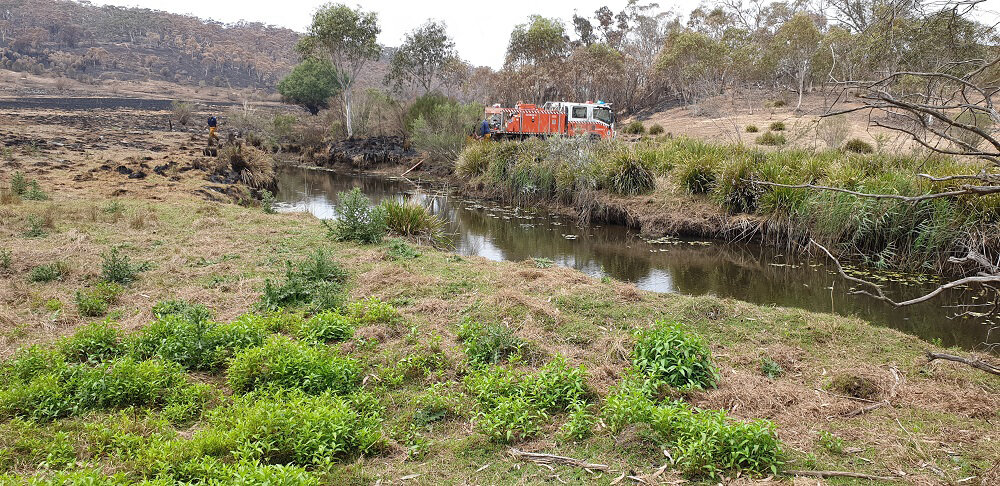
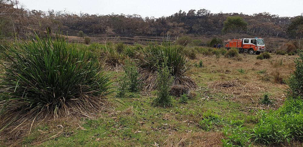
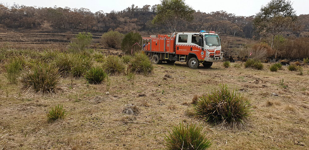
On the 10th of January 2020, the Currawan (renamed locally as the Charleys Forest) fire burnt through two thirds of Peter and Donna’s 350ha property, Baarlijan, near Braidwood. Many firies and locals along a 10km front fought to pull the fire up before it could make yet another run towards Mongarlowe and Braidwood. All of them needed water!
Fortunately, they found it in ponds dotting the intact valley floor at Baarlijan in a hydrated part of the landscape that proved much more resilient to the fires. The fire trucks were able to safely rewater in this green oasis, surrounded by a desiccated landscape just wanting to burn, before continuing to fight the fire.
Pictured is the Sunshine Coast Strike Team from Queensland – Alex, Ray, Trevor, Garry and Martyka, rewatering at what Peter and Donna call ‘Opera House Pond’.
Thank-you to everybody who has helped to fight these fires!
Given the circumstances at the end of 2019 and the start of 2020, I find it difficult to use the “H” word in front of “New Year” that under normal circumstances I would start my message with at this time.
Things are certainly not normal at the moment with so much of the country burning at such devastating levels. Thousands of houses gone, lives lost and landscapes looking like moonscapes. While there is and will continue to be debate about why this has happened, who is to blame, what we can do to prevent it happening again, etc, at The Mulloon Institute (TMI) we know that hydrated landscapes don’t burn like we have witnessed in recent weeks.
Well before the fires started we had witnessed an increasing interest in our work as the extended drought made farmers and landholders rethink the way they farm and manage their land. As Charles Massy said at our Field Day last November, “It takes crises to shock people into change”. If this isn’t a crisis I don’t know what is.
So, in 2020 TMI will be upping the ante on landscape rehydration. We have been demonstrating the value of rehydration to the environment, the increased agricultural production, to resilience during drought, to increased water retention and to communities. Now add resilience to bush fires. We won’t stop bush fires but rehydrated landscapes will act as a deterrent and reduce the ferocity of them.
In the aftermath of the fires, town and city water supplies will also come under pressure due to polluted runoff from burnt catchments. The work we have done and continue to do is by far the best solution.
Our own Mulloon Community Landscape Rehydration Project (MCLRP) will help filter and clean runoff from the Tallaganda National Park fire as it flows into the Shoalhaven and on to Sydney’s water supply. Similar work needs to commence urgently in all burnt catchments that service towns and cities. In fact, landscape rehydration work will be one of the best practical actions communities can take to improve their water quality after the fires.
Most importantly, our work offers hope that landscapes can be repaired and rebuilt, making them more resilient to extreme weather events such as the bushfires we have witnessed across our country this summer.
I will return to my ‘normal’ Chairman’s update at the end of the month to cover recent activities, but I feel that with the fire crisis still playing out around us it is important to let all our followers and supporters know that we intend to play a significant role in responding to the events of the past month.
Regards Gary Nairn AO Chairman, The Mulloon Institute
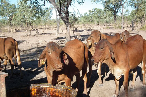
[Image: On-ground works at Mt Pleasant Station, Queensland supplied by NQ Dry Tropics]
Landscape rehydration ‘better than dams’ in improving farm production, reducing fire risk
Chris Le Feuvre (centre) says the sediment traps on this gully have prevented soil loss and improved rainfall penetration. (ABC Rural: Tom Major)
The leaders of a project to rehydrate the landscape of a north Queensland cattle property say the results are proof that profits can flow from keeping more scarce rainfall on-farm.
Grazier Chris Le Feuvre, from Worona Station between Townsville and Charters Towers, said his property was a degraded landscape with significant erosion issues before changes were made a decade ago.
“There were a lot of cattle here, basically living on leaves falling off trees and molasses,” he said.
Since 2015, a project to rehydrate Worona Station with assistance from NRM group NQ Dry Tropics and the consultancy arm of the Mulloon Institute has rehabilitated the country.
Splitting paddocks into small sizes and using large mobs of cattle grazing on rotation, Mr Le Feuvre is grazing pasture more intensively while giving it longer to rest, increasing carrying capacity.
Profitability has increased, with the comparatively small 6,677-hectare northern operation now providing full-time stable employment for the owner and his son.
Reducing the need for costly supplement is a key aim of Worona Station grazier Chris Le Feuvre (Supplied)
“They do better now, also the species of grass and plants are changing, there’s more variety now,” Mr Le Feuvre said.
“We’ve got twice the cattle we had here before, we’re up to 2,000 head … we’ve got groundcover everywhere and there’s enough feed to go until the end of January.
“We want all plants to grow: the more groundcover you have, when it does rain you’ll have more rain infiltrating the soil.”
Mulloon Institute chairman Gary Nairn said the issue of degraded gullies and streams was a national concern.
“We are pushing hard to get a change in attitude … it will assist dramatically in making the agricultural sector resilient to extremes that come along,” he said.
“In getting a rehydrated landscape you become more resilient to fire, drought, it also mitigates some of the flooding aspects.
“It’s all about slowing the water down, holding it in the landscape longer.”
Eroded catchment gullies created by mining, over-grazing or vehicle tracks have been mapped for remediation planting (Supplied: NQ Dry Tropics)
Erosion focus
Using cattle-grazing techniques where stock are moved from small paddocks on a regular basis and engineering works, the property’s sediment runoff levels have reduced.
Sam Skeat, grazing officer with NQ Dry Tropics, said remediating gully erosion was a key factor in keeping damaging topsoil out of the Great Barrier Reef area.
“Once water would get into this gully you wouldn’t see it again, it’d end up in the Haughton (River) and end up in the sea,” he said.
“Chris implemented some structures to get that water back up interacting with that landscape on the soil surface and growing more grass.”
The plug-and-pond technique — also known as leaky weirs — involves small dam-like structures to lift the bed level of the water, which is then run onto the floodplain to grow pasture and recharge aquifers.
While weirs have been strategically constructed, Mr Skeat said grazing management was the most important tool to improve water retention in a landscape.
“We always say to people you can cover 99 per cent of your company with grazing and 1 to 2 per cent with the intervention in gullies,” he said.
“If you can use cattle as a tool to regenerate the grassland, you’ll get more infiltration, slow the flow, hold water up in the landscape and have you growing grass for longer.”
Vegetation cover has improved on Worona Station to the point where nine-month gaps between rainfall can be accounted for (ABC Rural: Tom Major)
‘Better than dams’
With significant Federal Government interest in the building of new dams and water storages, funding is underway for several feasibility and business cases.
However Mr Nairn, a former cabinet minister in the Howard government, said landscape rehydration offered much greater possibilities.
“I don’t deny that there are some needed strategic dams, but nowhere near the wholesale building of dams that some advocate,” he said.
The Mulloon Institute, founded to promote the Peter Andrews method of land rehydration, has been demonstrated near Braidwood, New South Wales along the Mulloon Creek.
Mr Nairn said he had shown Prime Minister Scott Morrison and Deputy Prime Minister Michael McCormack that the potential for storing water in soil was significant.
“We’ve been able to demonstrate in Mulloon, if we repaired and rehydrated the catchment through to the Sydney water supply, you could store the equivalent of Warragamba Dam,” he said.
“It’d cost billions to build another Warragamba Dam but it won’t cost billions to restore that landscape to a naturally functioning one.”
With the recent announcement of a $5 billion annual Future Drought Fund to better prepare communities for climate change, Mr Nairn said the opportunity for rehydration was obvious.
“The language around that is all about spending that money for resilience … so I’m encouraged by that,” he said.
“I think it needs a lot more [money] than that to get work happening on rehydration of the amount of land that needs to be done.”
Levels at Warragamba Dam, which supplies about 80% of Sydney’s water, have dropped to less than half capacity (ABC News: Geoff Kemp)
Carbon banking for water
Mr Le Feuvre said building up the soil carbon content during the past decade meant more water stored in the soil, a critical factor when rain falls intensely across a short period in the tropics.
“If you go around and measure the soil infiltration rates, some places are lucky to infiltrate half an inch (12mm) of rain an hour,” he said.
“I know of people who can infiltrate 16 inches (406mm) of water an hour; if you can build your soil and organic matter to that sort of level, you can make more use of the rain.
“I believe we’re getting enough rain, we’re just not using it. We’ve got increased run-off, gully erosion … when we get rain, it’s falling on hard, bare soil.”
Mr Nairn agreed that landholders needed to become much better at using scarce rainfall to gain the maximum value from moisture.
“Hydrating that landscape, so that the value of it lasts a lot longer, if you get long periods of dryness,” he said.
Mulloon Consulting general manager Carolyn Hall said money raised though the group’s work was used to lobby for more government drought scheme grants.
“We’re making submissions wherever we can on those programs and highlighting our work,” she said.
“Making sure politicians and decision-makers are aware of what we’re doing … how this work can assist with erosion and positive impacts on the Great Barrier Reef.
Additional funding could come from the Queensland Government’s recently released plan to spend $500 million on expanding a pilot Land Restoration Fund program.
Under the scheme to increase the number of carbon credits produced in the state, long-term purchasing agreements will be signed with landholders.
The Government has promised that decisions to fund projects will be based on co-benefits, including increasing social and economic value to communities.
A group of adult yellow-spotted bell frogs, a species previously thought to have been extinct, has been released at a property near Bungendore.
Twenty frogs have been set free at Mulloon Creek Natural Farms as part of a trial program to see how they fare in the wild. Radio transmitters have been attached to the frogs to track progress.
For 30 years the yellow-spotted bell frog was presumed extinct, but in 2009 a small colony of the frogs was found on a small stretch of creek line north of Yass.
Researchers recovered tadpoles and developed an in-situ colony at Taronga Zoo. The zoo’s fauna supervisor Michael McFadden said the species had been “secured” at the colony.
“Over the last couple of years now we’ve had a bit of success breeding them and we have been trialing reintroduction at a couple of sites,” he said.
Since 2017, six clutches of eggs have been released by frogs at the zoo and Mr McFadden said close to 2000 frogs had been reintroduced back into the wild.
Mulloon is the third site where the frog has been reintroduced with releases at two other sites in the Southern Tablelands.
“The folks at Mulloon have got some beautiful rehabilitated creek line which looks like absolutely excellent bell frog habitat,” said Mr McFadden.
While the drought posed a risk to the frogs it does lessen the chance of the frogs developing the chytrid fungus – an infectious virus that affects amphibians worldwide as the virus thrives in cold and wet conditions.
“I was concerned… why would they be releasing the frogs in the middle of the worst drought we’ve ever had, even though there is water in the creek,” said Mulloon Institute project coordinator Peter Hazell.
“But they suggested that it’s quite possibly the best time to release them because the chytrid fungus would be the least active during the drier times.”
Unfortunately for this batch of 20 frogs, the survivability does not look great. A few have already been taken by snakes and another by a kookaburra. Two more have kicked off their radio transmitters, Mr Hazell said.
“This is just a pilot program to figure out where they go and effectively what eats them… and whether they get the chytrid virus,” he said.
“I don’t think they are expecting any survivability for this lot but as they continue to breed their frogs in captivity they will probably start to undertake more mass translocations back into these particular sites.
“That’s the thing about frogs, everything wants to eat them.”
Despite the losses so far, if the program is deemed a success they have planned to do a “rolling release” of the frogs at Mulloon. The plan is to reintroduce thousands of frogs back into natural habitats across the Southern Tablelands and surrounds.
“The species have been secured in the in-situ colony at Taronga Zoo and now we are taking the first steps at reintroduction and over the next couple of years we will be furthering it,” said Mr McFadden.
“Potentially at Mulloon and at other sites as well to see where we can hopefully establish some self-sustaining species of the population again.
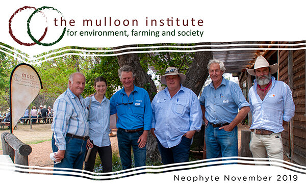
On behalf of the Board of The Mulloon Institute (TMI) I trust you enjoy reading about our activities over the past year covered in this Annual Report. The interest displayed by an ever increasing number of followers and supporters has been wonderful to see and helps to ensure the ongoing success of TMI and the work we are doing.
Discussing floodplain soil characteristics. Note the sandy gravel soil present under the medium black clay.
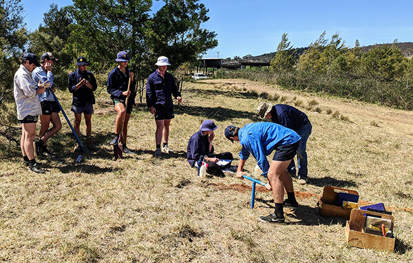
Year 12 Plant Production students from The Scots College visited Mulloon Creek Natural Farms during November to learn about soils and how different soil characteristics impact plant growth, water infiltration and soil water holding capacity.
The two day visit began with a screening of Rehydrating Australia and Regenerating the Australian Landscape to give the students an overview of Tony Coote’s vision for TMI and an introduction to the issues we are working to address.
Day one commenced at the excavated soil pit, with discussions around soil characteristics and their implications for growing plants, and the water infiltration rates of different soils and their water holding capacity relative to the location in the landscape. They learnt how to conduct ‘soil characterisations’ using augers to extract soil core samples. They identified the different horizons (A1, A2, B1, etc), photographed and described the colour, texture assessment (sandy clay, medium clay etc), and tests for; pH, slaking/dispersion, soil organic carbon, calcium carbonate and root zone depth. Further discussions surrounded key elements of each group’s soil profile, how and why they were different, processes for reading the landscape, and how plants play a vital role (slowing water movement) in helping the soil harvest water (infiltration) for the benefit of plants and the soil biome.
Day two activities went on to conduct soil augers in the floodplain zone. The student groups chose test sites ranging from the edge through to the middle of the floodplain and uncovered slightly different soil profiles at each. One site had a thin layer of fine sand at approximately 75cm with a silty clay overlay, suggesting a previous minor fluvial channel. Another had a small, rounded metasedimentary pebble layer at approximately 45cm depth, suggesting this was a more pronounced fluvial stream running through the floodplain and was now part of the higher ground in the floodplain. In all, variability in the soil profile was present, however the general profile consisted of sandy/clay loam in the A horizons, with light to heavy clays in the B horizon. The pH was consistently 6-6.5 (that’s good), with test for SOC (soil organic carbon) indicating a positive in many of the A horizons (good), good root nodules and soil aggregates, with roots noted on average to a depth of 75-100cm. Notably the soil was dry in the A1 horizon, however there was some moisture in the lower horizons. Each group then presented their soil profiles to the class and explained what they had discovered.
In addition to the soil characterisation activities, students were taken on site visits that included the step diffusion site on sloping country and the creek rehabilitation works at Peter’s Pond to identify different landscape processes and how they connect and interact.
We look forward to welcoming students from The Scots College (and other interested schools) to Mulloon Creek Natural Farms in the future for similar field trips which can be tailored to suit specific curriculum and educational outcomes. Contact us via info@themullooninstitute.org to find out more.
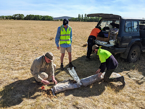
Conducting soil sampling on a mid-slope hill site to identify the layers and their physical and chemical characteristics.
World Soil Day 2019
Date published: 5 December 2019
Soil scientist Wayne Cook inspecting soil sample at Duralla, with TMI’s James Diack and work experience student James Hunt.
#WorldSoilDay
Over the last two weeks we’ve had a professional drill rig unit onsite from Terratest extracting soil core samples as part of our baseline monitoring work in the Mulloon Community Landscape Rehydration Project. The drill rig work was overseen by TMI’s Soil Hydrologist Tony Bernardi and used a sonic vibration method to extract the soil cores, which were then expertly handled by Soil Scientist Wayne Cook.
The drill unit took samples down to as deep as 30 metres to identify the underlying bedrock. The soil cores revealed an amazing look back through history of alluvial and aeolian processes that have formed the floodplain soils of today. They encountered soils of varying depth and characteristics, such as slicing through clay and rich organic soils, and at other times old river rocks, gravel and sand. Most fascinating were the seams of sand (and/or gravel) running through the landscape at different levels. These sandy layers often have a clay layer underneath or above, indicative of multiple aquifers, and act like underground rivers or veins in the ground, allowing water to move through the landscape. This allows water to be distributed and stored in these clay layers, effectively ‘banking’ water in the soil for use during drier times.
Soon these drill holes will have piezometers installed in them to allow for ongoing monitoring of groundwater depth and quality throughout the MCLRP.