The Landscape Function Toolkit (LiFT) project, equipping Australia with a systems-approach to landscape climate resilience is supported by the Australian Government through funding from the Climate-Smart Agriculture Program under the Natural Heritage Trust. The 3.5 year grant will fund development of LiFT to equip land managers, farmers and First Nations’ peoples with the skills and tools to monitor the function of their landscapes and take action to increase the health and resilience of agricultural landscapes in the face of climate change.
We invite you to take part in a short survey designed to gather insights into landholder preferences around monitoring. Your input will help us develop a Landscape Function Toolkit aimed at supporting positive change in landscape health.
Introduction
Climate-smart agriculture needs cost-effective, accessible ways to implement whole-of-system approaches to building and measuring landscape resilience. The LiFT project meets this by platforming landscape function, a scientific framework for effective decision-making and monitoring. Functioning landscapes retain essential resources (water, nutrients) and bounce back from natural disasters and other shocks, however dysfunctional landscapes leak resources becoming progressively more vulnerable.
Our environment is forever being shaped by two sources of energy: the sun, and gravity compelling water and anything it can carry downhill. Without plants buffering these forces, these forms of energy would continually desiccate and erode our landscapes and waterways. Functional landscapes have a high capacity to buffer this energy. Functional landscapes maintain basic processes such as capturing and dissipating energy; retaining, using and cycling water and nutrients; providing habitats for biodiverse populations of plants, animals and micro-organisms; and sustaining people by providing their material, cultural and spiritual needs. On the other hand, dysfunctional landscapes have impaired capacities for one or more of these functions. Restoring a disturbed landscape means repairing its damaged functions. A resilient landscape is one that can resist or bounce back after a shock such as a drought, flood, or fire. Landscapes are resilient when biological, physical and chemical processes are optimally contributing to the healthy cycling of water, carbon, and nutrients between the atmosphere and the landscape system. A functional landscape is a resilient landscape.
This project will create a landscape function toolkit which is co-designed with technical experts, scholars and First Nations and tailored to natural capital markets and Nature Repair compliance frameworks. It will provide accessible workflows and methods adaptable to diverse agricultural enterprises and monitoring technologies. LiFT will meet the need for simple tools to manage complex landscape systems in the face of climate change and thrive in a sector that is rapidly incorporating the Nature Repair agenda. The innovative value of this project lies in its whole-of-system approach by bringing passionate experts together to formulate an easy-to-understand, streamlined pathway for landscape function-oriented measurement and decision-making. The methodology of landscape function is the most integrated methodology for tracking landscape health.
Like the widely respected Rapid Assessment of Soil Health (RASH) strategy, and the Rapid Assessment of Riparian Condition (RARC), it builds on rigorous empirical science (Tongway & Ludwig 1996) but is highly accessible. LiFT doesn’t just focus just on carbon, vegetation, or soil, but will also integrate an array of indicators. A data capture and display platform will be developed, based on monitoring modules that can be selected, based on scale and budget. Communities of practice will be developed through Mulloon Institute’s existing nationwide education and capacity building program. Landholders will be provided with an opportunity to test drive the tool, apply it to their own farms, and support uptake of LiFT to monitor the impact of changes in land management and repair.

Challenge
In Australia, deforestation and agriculture have caused widespread erosion of soils, biodiversity loss and waterway degradation. This has made many of our productive landscapes dysfunctional, because they cannot store and cycle the water and nutrients they need. Climate change is amplifying these vulnerabilities, and farming landscapes cannot thrive with an ever-depleting natural resources base. The extent of hydrological dysfunction in Australia’s productive landscapes is underestimated, as is the role of water cycling in mitigating climate change. It confuses many stakeholders because so many parts of the water cycle are invisible and difficult to perceive. Monitoring of landscape health indicators is complex, expensive and technical, with workflows designed for academics and specialists rather than laypeople. The sector is struggling with siloed methods and single-issue monitoring like carbon, which is expensive and fails to define agricultural landscapes as complex adaptive systems.
Workflows are currently presented in text-heavy formats, resources are outdated and there is a scarcity of straightforward communication materials. Landscape monitoring is also labour-intensive and costly, stifling beneficial action, because data is often not available to verify the credibility of worthwhile projects, and there is poor literacy of landscape systems and landscape resilience principles. This project aims to fill the gap, by bringing landscape function monitoring to life and disseminating it in innovative ways. A well-designed landscape function methodology can equip land managers to diagnose and prioritise problems, assess the baseline condition of a landscape, plot trajectories of stabilisation and resilience with benchmarks and conduct well-organised monitoring of results of land restoration projects. Straightforward, well communicated models of practice that serve all stakeholders are needed.
Opportunity
The Landscape Function framework is widely respected in both NRM and agriculture sectors because it can bridge farming eco-restoration domains of knowledge and practice. The methodology of landscape function is the most integrated methodology for tracking landscape health. It integrates strategic goals regarding drought, fire and flood resilience, can be adapted to enterprise contexts and synthesise objectives relating to biodiversity, carbon, water quality, and many other indicators of landscape resilience critical to align with nature repair private finance and government objectives. The restoration of landscape function is a high leverage strategy compatible with a range of best-practice approaches to sustainable natural resource management and able to be incorporated into any agricultural enterprise. By reducing the complexity of landscape systems to key indicators of function and dysfunction and guiding land managers to track positive and negative trajectories of change, it has immense potential to drive change. LiFT will streamline the monitoring of landscape function improvements and support wider uptake of nature-based solutions, improved land management for climate resilience and improved biodiversity and social outcomes in rural and First Nations communities.
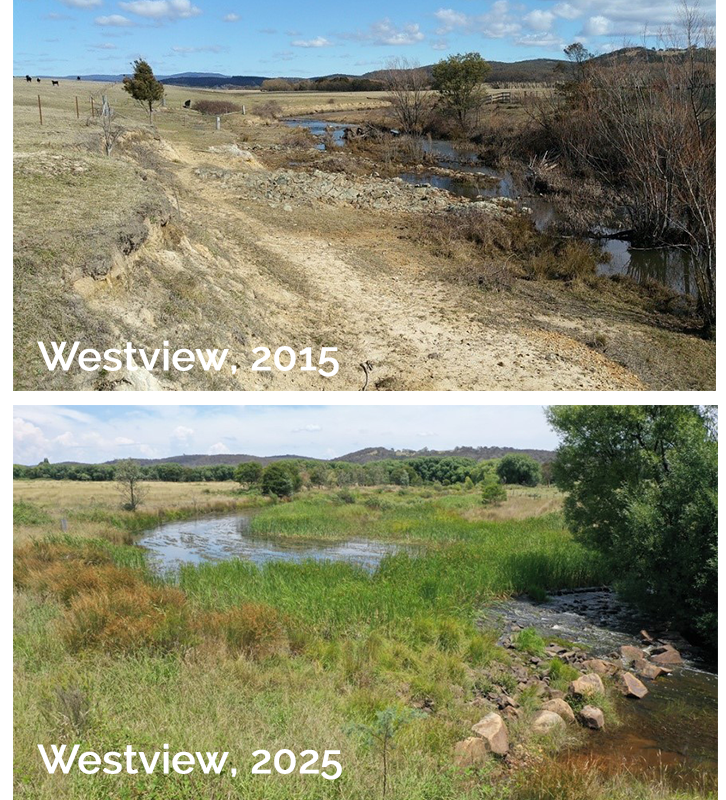
Pictures at left. TOP: dysfunctional landscape showing poor density and diversity of vegetation, with poor stream condition. BOTTOM: a repaired a functional landscape with well established vegetation, increasing habitat complexity and acting to de-energise high flows.
Passionate experts will formulate an easy-to-understand, streamlined pathway for landscape function-oriented measurement and decision-making. Consortium partners include Aurecon, WaterNSW, Commonland, Regen Farmers Mutual, The Borevitz Lab (ANU), CiboLabs, HydroTerra, Top End Conservation Management and Australian Rivers Institute (Griffith University). Two renowned regenerative farmers will provide expert landholder perspectives and Noongar Land Enterprise Group, Kooma Traditional Owners Association Inc. and Landcare NSW’s Aboriginal Partnerships Manager will provide a First Nation lens. Drought Innovation Hubs in South-West WA, southern NSW and NT’s Northern Hub will provide knowledge broker support.
LiFT will be underpinned by relevant technical knowledge and research by the Australian Rivers Institute, leaders in meeting the challenge of water security and sustaining aquatic systems in the face of climate change. Australian farmers are aware of the emerging carbon and natural capital markets but are reluctant to enter due to barriers around the costs of baselining, risk appetites, low trust levels in methodologies and long time-frames for returns. A streamlined, cost-effective monitoring toolkit that can be applied to the project or catchment scale, capture qualitative and or quantitative data to measure landscape change will bring confidence to famers to implement change and engage with markets. Its incorporation of up-to-date financial analysis to ensure the monetary value of monitoring data to potential funders and within natural capital markets will be integrated into LiFT, with Aurecon and Regen Farmers Mutuals expertise. This can multiply the funding pathways for sustainable land management that can benefit the Australian agriculture sector, and help farmers swiftly adapt so they can be compliant with emergent Nature Repair compliance frameworks.
First Nations perspectives on Country are about a whole-of-system view and will enrich the co-design process. LiFT will build on current monitoring knowledge and best practice from Water NSW, the Australian Rivers Institute and Mulloon Institute to bring the role of healthy water cycling to the forefront of landscape function monitoring and action. Existing frameworks, like those developed by the Australian Rivers Institute and currently in use by Water NSW, will be used. The experience, values and views of the working group, will ensure that landholders and First Nations have a voice, along with partners with strong academic and technical backgrounds. Mulloon Institute’s Science Advisory Committee will also provide oversight and advice on the co-design of LiFT. The process will include an opportunity to practically apply LiFT to existing and new landscape repair projects, quickly testing, refining and streamlining the tool. This project will create a highly accessible tool, that fast tracks land holder understanding of indicators of landscape function and dysfunction and accelerates their ability to respond and report on progress. In a co-design process, LiFT will be delivered suitable for field trials and support projects targeted to landscape-scale or catchment-scale outcomes that require a whole-of-system’ approach in NSW, WA and NT.
The diversity of consortium members and inclusion of First Nations groups in co-design will drive high quality science communication to create widely accessible tools, workflows and guidelines shareable in a variety of formats (slidedecks, videos, infographics). LiFT will be supported by science communication tools that set out the benefits of landscape repair for climate resilience including animations, films and gamification of challenging concepts. A data capture and display platform based on monitoring modules that can be selected based on scale and budget, will support engagement with the tool. Communities of practice will be developed through Mulloon’s existing nationwide education and capacity building program supporting the practice change required to transition management and restoration of agricultural landscapes for climate resilience.